
Severe Weather Risk Expands From the Plains Toward the Midwest Early This Week
Severe storms possible across the Plains over the next few days
A period of active weather is setting up for parts of the central United States, with severe thunderstorms possible across the Plains over the next few days. The overall message for residents and travelers is straightforward: the risk may not be limited to a single afternoon or a narrow corridor. Instead, the threat could persist for several days and may expand eastward as the week progresses.
Forecast guidance indicates that the severe weather threat could also spread to parts of the Midwest and parts of the Mississippi River Valley by mid-week. That means communities that start the week outside the highest-risk zone should still stay alert, especially as the forecast evolves and the most likely areas for storms shift from day to day.
What hazards are on the table: hail, damaging winds, and tornadoes
The potential threats include hail, wind gusts, and tornadoes. Each of these hazards can create dangerous conditions quickly, sometimes with limited warning time, and each can impact daily routines in different ways.
Hail: Hail can range from small pellets to larger stones capable of damaging vehicles, roofs, and windows. Even brief hail bursts can create hazardous driving conditions and lead to sudden property damage.
Wind gusts: Severe thunderstorm wind gusts can bring down tree limbs, damage structures, and cause power outages. Strong winds can also make travel difficult, particularly for high-profile vehicles.
Tornadoes: While tornadoes are not guaranteed in every severe weather setup, they are among the most serious threats mentioned in the forecast. Tornado risk can vary by location and time, and it can change as storms develop.
Because these hazards can occur in different combinations, the practical takeaway is that people should be prepared for rapidly changing conditions—ranging from intense downpours and hail to damaging straight-line winds and, in some cases, tornado potential.
Cities that could see days of severe weather
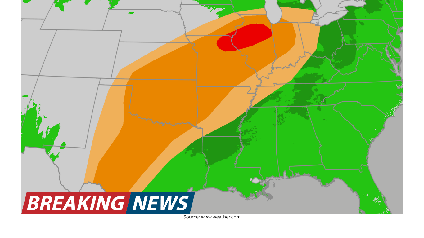
The potential impact zone includes several major population centers. Cities like Dallas, Oklahoma City, Kansas City, Chicago, Des Moines, Minneapolis, Detroit and St. Louis could see days of severe weather. The inclusion of multiple cities across a wide geographic area underscores how this threat is not confined to one region.
It is also notable that the list spans from the southern Plains into the central Plains and toward the Upper Midwest and Great Lakes. That broad reach is consistent with the expectation that the threat could begin in the Plains and then spread into parts of the Midwest and the Mississippi River Valley by mid-week.
How the threat may evolve through mid-week
Early in the week, the primary concern is focused on the Plains, where severe storms are possible over the next few days. As the week continues, the threat could also spread to parts of the Midwest and parts of the Mississippi River Valley by mid-week. In practical terms, this suggests a scenario in which the corridor of greatest concern shifts eastward and/or expands, potentially bringing repeated rounds of storms to some areas.
Repeated storm chances matter because even if one day’s storms are limited, a multi-day period can increase the odds that at least one round becomes severe in a given location. It can also complicate recovery if storms cause damage on successive days. For those in the highlighted cities and surrounding areas, the key is to treat this as an evolving, multi-day forecast rather than a single isolated event.
What “days of severe weather” can mean for planning
When a forecast mentions that certain cities could see days of severe weather, it can affect everything from commuting and school schedules to outdoor work and travel plans. Even without knowing the exact timing of each storm round, the possibility of multiple severe-weather days is a signal to build flexibility into the week.
For example, outdoor events may need contingency plans, and those who rely on travel between metro areas may want to monitor conditions not just at their destination but along the entire route. Because the listed cities are major transportation hubs, disruptions—whether from storms themselves or from precautionary measures—can ripple outward into surrounding communities.
Key areas to watch: Plains first, then Midwest and Mississippi River Valley
The forecast emphasis begins with the Plains. That includes areas near major cities such as Dallas and Oklahoma City, where severe storms are possible across the Plains over the next few days. As mid-week approaches, attention may need to broaden to include parts of the Midwest and parts of the Mississippi River Valley.
For people in the Midwest—such as those near Chicago, Des Moines, Minneapolis, Detroit, and St. Louis—the mid-week timeframe is particularly important. Even if early-week conditions are quiet, the threat could arrive later, and the hazards listed (hail, wind gusts, and tornadoes) can develop quickly when the atmosphere becomes favorable.
Why staying updated matters during an active pattern
During an active severe-weather pattern, conditions can change quickly. The forecast calls for severe storms to be possible across the Plains over the next few days, and it notes that the threat could spread to parts of the Midwest and Mississippi River Valley by mid-week. That kind of evolving setup makes frequent updates important, especially for those in or near the cities that could see days of severe weather.
Even within a single metro area, the severity of storms can vary significantly depending on where the strongest cells track. Someone on one side of a city might experience heavy rain and lightning, while another area sees hail or damaging winds. The mention of tornadoes adds another layer of urgency to staying informed when storms are in the area.
Safety reminders for severe thunderstorm and tornado threats
With hail, wind gusts, and tornadoes listed as possible threats, it is worth reviewing basic severe-weather safety steps. These are general reminders that can help people respond quickly if warnings are issued.
Have multiple ways to receive alerts: Severe weather can develop at any time of day. Using more than one method to receive warnings can reduce the chance of missing critical information.
Know where to go if storms intensify: Identify a safe place ahead of time, particularly if tornadoes become a concern. Planning in advance can save valuable minutes.
Protect property when possible: If hail is expected, moving vehicles under cover can reduce damage risk. Securing loose outdoor items can help when strong wind gusts are possible.
Adjust travel plans as needed: Severe storms can create sudden hazards. If storms approach, delaying travel or taking shelter may be safer than trying to outrun the weather.
These steps are not a substitute for local instructions, but they reflect the types of hazards that can accompany severe thunderstorms—especially when the forecast includes the possibility of tornadoes.
What to watch for in the day-to-day forecast
Because the threat may last multiple days and could expand geographically, the day-to-day forecast becomes important. The core hazards—hail, wind gusts, and tornadoes—can vary depending on storm mode and timing. Some days may feature a higher risk of damaging winds, while other periods may favor hail or a greater tornado concern. The forecast also highlights that the threat could spread into the Midwest and Mississippi River Valley by mid-week, which means the focus areas may shift.
For residents in the cities mentioned—Dallas, Oklahoma City, Kansas City, Chicago, Des Moines, Minneapolis, Detroit, and St. Louis—this is a good week to pay attention to how each day’s outlook is framed. The phrase “could see days of severe weather” suggests that more than one round of storms may be possible, and that the most impactful day may not be the first day storms appear.
Bottom line
Severe storms are possible across the Plains over the next few days, and the threat could also spread to parts of the Midwest and parts of the Mississippi River Valley by mid-week. The hazards include hail, wind gusts, and tornadoes, and several major cities—Dallas, Oklahoma City, Kansas City, Chicago, Des Moines, Minneapolis, Detroit, and St. Louis—could see days of severe weather.
In a setup like this, the most useful approach is to treat the forecast as a multi-day situation: stay aware of updates, be prepared for changing conditions, and take warnings seriously if storms develop in your area.