
Florida Braces for Rounds of Rain: Drought Relief Arrives With a Flooding Caveat
A week of changing weather for the Florida Peninsula
Florida is expected to see multiple rounds of rain and storms this week, a shift that could bring long-awaited relief to parts of a drought-stricken state. The outlook, however, comes with an important warning: in some locations, rainfall may arrive too intensely and too quickly, increasing the potential for flooding concerns for millions.
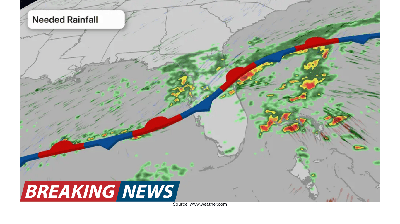
The forecast centers on a series of weather features moving across the region over several days. The first round of rain is already moving through into Tuesday as a cold front stalls over the state. That setup is expected to be enhanced by an upper-level disturbance, helping to spread rainfall across much of the Florida Peninsula.
After that initial push, conditions are expected to briefly ease. Wednesday is forecast to bring a slight lull before another surge of moisture returns Thursday. By Friday, the bulk of the rain is expected to wrap up, an important detail for residents and visitors looking ahead to weekend plans.
Where the heaviest rain is expected
While rain is forecast to be widespread, the heaviest totals are expected along Florida’s eastern coastline through Friday. Forecast rainfall amounts point to widespread totals above 3 inches in that corridor. In addition, isolated totals above 5 inches are possible if slow-moving storms repeatedly track over the same areas.
That possibility is one reason certain communities are being urged to pay close attention to changing conditions. Cities such as Daytona Beach and Melbourne are among those that may need to be on alert during the week, given the potential for higher-end totals if storms linger.
Rainfall distribution is expected to vary notably across the state:
East coast of Florida: Heaviest rain through Friday, with widespread totals above 3 inches and isolated amounts above 5 inches possible in slow-moving storms.
South Florida (including Miami): Totals of 1 to 3 inches are expected.
North Florida (including Jacksonville) and the Panhandle (including Tallahassee): Around an inch is possible.
Even within these broad ranges, local outcomes can differ significantly depending on how storms develop and whether they repeatedly move across the same neighborhoods. That is especially true during periods when storms are slow-moving, a scenario that can quickly raise rainfall totals and intensify runoff issues.
Why “much-needed rain” can still create problems
The week’s forecast underscores a complicated reality: rainfall can be both beneficial and disruptive, depending on how fast it falls and where it concentrates. Florida needs rain, and drought relief is expected in parts of the state. But the same pattern that brings relief can also create hazards when rainfall rates become too rapid.
Forecasters note that some places could see rapid rainfall rates. When rain falls that quickly, the soil may not be able to absorb it efficiently. As a result, flooding should not be ruled out—particularly in urban areas where water can pool quickly and drainage systems can be overwhelmed.
This is a key concern when storms are not only heavy but also slow. In that setup, rainfall accumulates over the same locations rather than being spread out over a wider area or longer period. The forecast specifically highlights the possibility of isolated totals above 5 inches if slow-moving storms move over the same areas, a scenario that can heighten localized flooding potential even when broader regional totals look manageable.
Drought conditions set the stage
The incoming rain is arriving as Florida faces one of its worst droughts this century. According to the U.S. Drought Monitor, the state is in the highest category of extreme drought (D3 of 4) at a level not seen in more than 25 years. The historical context is also important: there were times with a higher amount of exceptional drought (D4 of 4), specifically in January 2000 and December 2011. Still, the current situation is severe enough that many communities are watching the forecast closely for signs of improvement.
Rainfall deficits help explain the urgency. Tallahassee, for example, has received only 6.50 inches of rainfall so far this year. For this point in the year, the average year-to-date total is nearly 15 inches—more than double what has been observed. Other cities, including Jacksonville, Orlando, and Daytona Beach, are also running well below normal.
These shortfalls are significant not only because they reflect dry conditions, but also because they shape how the landscape responds when rain finally arrives. Dry patterns can increase the desire for soaking rain, yet they can also make it harder to achieve immediate drought relief if precipitation comes in intense bursts rather than steady, moderate amounts.
How drought-stricken soil can influence flooding risk
One of the week’s central themes is that drought-stricken soil does not handle fast rainfall very well. The ground typically needs steady rain over time to begin chipping away at drought conditions. When rain falls too quickly, a larger share of it can become runoff rather than soaking into the soil.
This dynamic can create a counterintuitive outcome: even as rainfall is welcomed for drought relief, short-term flooding risk can rise. The forecast discussion points out that if rain falls too quickly, it can lead to runoff and eventually flooding. That concern is amplified in urban settings, where pavement and other hard surfaces limit absorption and push water toward streets and low-lying areas.
In practical terms, this means the benefits of the week’s rain may depend not only on how much falls, but also on the pace at which it arrives. A widespread, steady rain would be better suited to helping the soil absorb moisture and easing drought impacts. Conversely, intense downpours concentrated in short windows may do less to relieve drought and more to create localized flooding issues.
Timeline: what to expect day by day
The forecast lays out a clear progression across the workweek, with alternating periods of active weather and brief breaks:
Into Tuesday: The first round of rain moves through as a cold front stalls over Florida. An upper-level disturbance is expected to enhance rainfall across much of the Florida Peninsula.
Wednesday: A slight lull is expected, offering a break between rounds.
Thursday: Another surge of moisture is forecast, bringing renewed rain and storm chances.
By Friday: The majority of the rain is expected to wrap up, which should help ensure weekend plans are not impacted.
This sequence matters for planning because it suggests that impacts may come in waves rather than as a continuous, multi-day event. It also highlights that the most significant totals are expected through Friday, especially along the eastern coastline, where repeated rounds could add up quickly.
East coast focus: why Daytona Beach and Melbourne stand out
Among the areas highlighted for close monitoring are Daytona Beach and Melbourne. The reason is not that rain will be limited to these cities, but that the heaviest rainfall is expected along the eastern coastline, and these communities sit within that favored zone.
Widespread totals above 3 inches are expected along the east coast through Friday. If storms slow down and repeatedly affect the same areas, isolated totals above 5 inches could occur. In that scenario, localized flooding becomes more plausible, particularly if heavy rain falls at rapid rates that exceed the ability of soil and drainage systems to absorb and move water away.
For residents, the takeaway is to pay attention not just to daily rain chances, but also to how storms behave—especially whether they are slow-moving and whether multiple rounds track over the same locations.
South, north, and the Panhandle: meaningful rain, different totals
Outside the east coast corridor, meaningful rainfall is still expected, though forecast totals are lower. Across the southern portion of the state, including Miami, totals of 1 to 3 inches are expected. In the northern part of the state, including Jacksonville, and in the Florida Panhandle, including Tallahassee, totals could be around an inch.
These differences matter in the context of drought. Some areas may see a more noticeable short-term boost from higher totals, while others may receive less rainfall than hoped. At the same time, even lower totals can be beneficial if they fall steadily, helping the ground absorb moisture rather than sending most of it into runoff.
Because the state’s drought is significant, the hope is that rainfall will be widespread and that rates remain at levels where the soil can actually benefit from the rain. That balance—between enough rain to help and not so much that it triggers flooding—will be one of the defining questions of the week.
What this pattern means for drought relief
The incoming rain is expected to provide some drought relief, but the forecast also makes clear that relief is not guaranteed to be uniform. Drought is a longer-term condition, and the soil often needs time and consistent moisture to recover. A burst of heavy rain can improve short-term conditions, yet if much of that rain runs off, the longer-term drought picture may not improve as much as raw rainfall totals suggest.
That is why steady rainfall is emphasized as the most helpful outcome. When rain falls at manageable rates, it has a better chance to soak in, replenishing soil moisture more effectively. When rain falls too quickly, it can lead to flooding concerns and reduce the efficiency of drought relief.
In other words, the same forecast can be read in two ways: as a welcome return of rainfall to a dry state, and as a reminder that timing, storm speed, and rainfall rates can determine whether the result is mostly beneficial, mostly disruptive, or a mixture of both.
Bottom line
Florida is headed into a wetter stretch, with rounds of rain and storms expected through the workweek. The first round continues into Tuesday as a stalled cold front and an upper-level disturbance help spread rainfall across much of the Florida Peninsula. After a slight lull Wednesday, moisture is expected to surge again Thursday, with most of the rain wrapping up by Friday—leaving weekend plans largely unaffected.
The heaviest rain is expected along the eastern coastline through Friday, where widespread totals above 3 inches are forecast and isolated amounts above 5 inches are possible if storms move slowly over the same areas. Daytona Beach and Melbourne are among the locations that may need to remain especially alert. Elsewhere, south Florida including Miami could see 1 to 3 inches, while north Florida including Jacksonville and the Panhandle including Tallahassee could see around an inch.
With Florida experiencing one of its worst droughts this century—and with cities such as Tallahassee far behind normal rainfall—this rain is needed. Yet forecasters caution that drought-stricken soil does not handle fast rainfall well, and rapid rainfall rates can lead to runoff and flooding, particularly in urban areas. The best outcome would be widespread rainfall that falls at a pace the soil can absorb, delivering meaningful relief without creating unnecessary flooding problems.