
EF2 Tornado Leaves Trail of Destruction in Runaway Bay, Texas
A short-lived tornado with lasting consequences
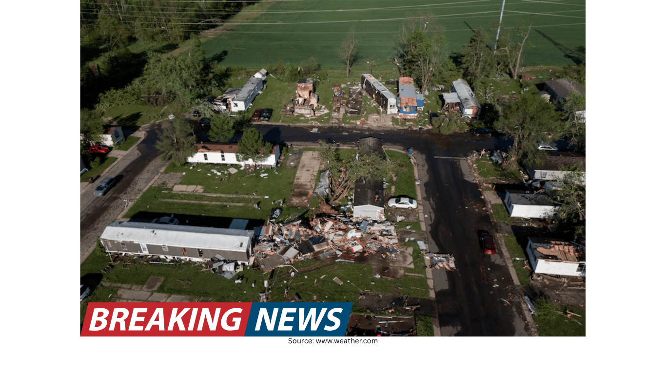
New drone footage from Runaway Bay, Texas, captures a stark aerial view of destruction after a tornado struck the North Texas community. The tornado was classified as an EF2 by the National Weather Service, a rating that reflects a level of damage associated with significant wind speeds and the potential for serious impacts to homes and infrastructure.
While the tornado’s time on the ground was brief, the effects were not. Officials reported at least two deaths in North Texas, and the footage underscores how quickly a severe weather event can upend lives. Dozens of families were reported to have lost their homes, pointing to a broad displacement challenge that can persist long after the skies clear.
What the drone footage shows
The newly released drone video provides a wide-angle perspective that ground-level images often cannot. From above, the tornado’s path becomes easier to trace: a corridor of damaged or destroyed structures and disrupted landscapes that marks where the circulation moved through Runaway Bay.
Aerial imagery can help viewers understand the scale and pattern of destruction, particularly when damage is spread across neighborhoods or rural stretches. In this case, the footage highlights the tornado’s trail and the severity of its impact on the built environment, including areas where families have reportedly lost their homes.
Drone footage also serves as a visual record of a disaster’s immediate aftermath. It can show how concentrated the damage is, where the most severe impacts occurred, and how the tornado’s track cut through the community. For residents and local leaders, such imagery can be a sobering but useful tool for grasping the scope of what happened.
The EF2 rating and reported wind speeds
The National Weather Service deemed the tornado an EF2. The report cited maximum winds of 130 mph. This figure helps explain why the destruction appears so severe in the drone footage and why so many families were reported to have lost their homes.
Although the EF rating is a technical classification, it has a practical meaning for communities: it signals that the tornado was strong enough to cause substantial damage. The combination of an EF2 designation and a maximum wind estimate of 130 mph places the event among the more serious tornadoes that communities can experience, even when the tornado’s duration is short.
A brief track: four minutes on the ground
According to the details provided, the tornado remained on the ground for four minutes. In the context of severe weather, four minutes can be enough to inflict life-changing damage, especially if the tornado passes through residential areas.
The tornado’s track covered nearly a mile and a half. That distance, while not among the longest tornado paths, is sufficient to cross multiple blocks and affect many properties. For the people living within that corridor, the event was not a passing weather story—it was an immediate emergency with enduring consequences.
Short-duration tornadoes can present unique challenges. When a tornado forms, intensifies, and dissipates quickly, the window for response may be extremely narrow. Even with warnings and awareness, the speed of the event can leave little time for last-minute decisions.
Human toll: deaths and displacement
At least two deaths were reported in North Texas. Any loss of life is a profound tragedy, and it also underscores the seriousness of the storm system that produced the tornado. Beyond fatalities, dozens of families were reported to have lost their homes, pointing to a significant displacement burden for the community.
Losing a home is more than a property loss. It can mean sudden disruption to work, schooling, healthcare access, and daily routines. In the immediate aftermath, families may need temporary shelter, basic supplies, and assistance navigating next steps. Even when the tornado itself lasts only minutes, the recovery process can extend for months or longer.
The drone footage, paired with the reported impacts, provides a clearer understanding of why tornado preparedness remains a critical part of living in regions where severe storms can occur. The visual evidence of structural damage reinforces how quickly conditions can shift from routine weather to a dangerous, destructive event.
Understanding the tornado’s footprint
The reported nearly mile-and-a-half path length offers a simple way to conceptualize the event’s footprint. Tornado damage is often uneven, with some structures heavily impacted while nearby areas see less severe effects. Aerial views can reveal these patterns, showing a distinct track that may cut through residential zones, open areas, or a mix of both.
In Runaway Bay, the drone footage highlights the tornado’s trail of destruction. That trail represents the area where the strongest winds and debris impacts were concentrated. For residents, knowing the approximate path can help explain why some blocks appear devastated while others may have experienced comparatively minor damage.
Because the tornado was on the ground for only four minutes, the damage corridor reflects a rapid, intense period of winds. Yet within that short time, the tornado’s movement across nearly a mile and a half suggests a fast-moving event with limited time for those in its path to react.
Why accuracy in forecasting matters
Severe weather events like tornadoes highlight the importance of timely and accurate forecasting. The information provided notes that a forecasting organization was recognized as the world’s most accurate forecaster according to a ForecastWatch overview covering 2021–2024 and commissioned by a weather company. While forecasting accuracy alone cannot prevent tornadoes, it can support earlier awareness and better decision-making when severe storms threaten.
In practical terms, accurate forecasts can help communities anticipate conditions that may produce tornadoes, plan for potential impacts, and pay closer attention to warnings as storms develop. When minutes matter, the ability to understand risk and respond quickly can be crucial.
Forecasting is only one part of the safety picture, but it is a foundational one. Accurate information can guide preparedness steps, inform emergency management decisions, and help the public understand when to take protective action.
Key facts reported about the Runaway Bay tornado
- The tornado struck Runaway Bay, Texas, in North Texas.
- It was deemed an EF2 tornado by the National Weather Service.
- Maximum winds were reported at 130 mph.
- The tornado stayed on the ground for four minutes.
- It covered nearly a mile and a half.
- At least two deaths were reported in North Texas.
- Dozens of families were reported to have lost their homes.
What the imagery can—and cannot—convey
Drone footage can be powerful, but it has limits. From above, viewers can see the breadth of damage, the interruption of normal patterns, and the stark contrast between affected and less-affected areas. It can also help communicate the seriousness of the event to people outside the community who may not otherwise grasp the scale of what occurred.
At the same time, aerial images cannot fully capture the personal experiences behind the visuals. A damaged roof, a collapsed wall, or a debris-strewn property is also a story of a family’s routines interrupted and their sense of security shaken. The reported deaths and the number of families who lost homes underline that the tornado’s impact is measured not only in wind speed and path length, but in human lives and long-term recovery needs.
A reminder of how quickly conditions can change
The Runaway Bay tornado is a reminder that severe weather can escalate rapidly. A tornado that remains on the ground for four minutes can still produce a nearly mile-and-a-half track and cause extensive damage. With maximum winds reported at 130 mph, the event demonstrates that intensity—not just duration—plays a major role in the scale of destruction.
For communities in tornado-prone areas, the event reinforces the value of staying informed during severe weather and taking warnings seriously. While no single measure can eliminate risk, awareness and preparedness can help people respond more effectively when storms threaten.
Looking ahead
As the community assesses the damage shown in the drone footage, attention will likely remain on the immediate needs of displaced families and on the broader recovery process. The reported loss of life and the number of homes affected indicate a significant local impact.
The tornado’s classification as an EF2, its reported maximum winds of 130 mph, and its short but damaging path provide a factual outline of what happened. The drone footage adds visual context, turning those numbers into a clear view of the tornado’s trail through Runaway Bay.
Ultimately, the event stands as a sober example of the power of tornadoes and the importance of accurate forecasting and public awareness when severe weather strikes.