
April Outlook Updated: Warmer Trends Expand, While the Northeast Stays Cooler
April’s updated monthly outlook: a warmer tilt for many, but not all
The updated April monthly outlook indicates that much of the United States is trending warmer than previously expected. The latest update—produced by The Weather Company and Atmospheric G2—shows above-average temperatures expanding across multiple regions, even as one part of the country continues to stand out as an exception.
The broad message is straightforward: many areas are forecast to run above average this month, while the Northeast is again singled out as the primary region expected to be below average. Alongside the temperature outlook, the precipitation forecast also points to wetter-than-average conditions across a large portion of the Central U.S., with a slight expansion in the wet signal for the Central Plains.
This update represents a meaningful shift from the earlier forecast, with several regions changing categories or intensifying their expected anomalies. In other words, it’s not just a routine refresh—there are notable adjustments that could affect how communities, travelers, and planners think about April conditions.
Where above-average temperatures are expected
According to the outlook, above-average temperatures are expected to stretch across a wide band of the country. The warmer-than-average area runs from the Pacific Northwest to the Southwest, continuing through the Central U.S. and extending into the Southeast. This creates a large, connected region where April is expected to be milder than typical.
That does not mean every day will be warm everywhere, or that late-season cold snaps are impossible. Monthly outlooks describe the overall tendency for the month compared to long-term averages. Still, the geographic footprint of the warmer signal is large enough to be a defining feature of the April forecast.
The updated map also underscores that the warmer trend is not uniform. Some areas are simply above average, while other areas are forecast to be well above average. That distinction matters because it signals a stronger departure from what is typical for April, at least on average across the month.
The main cool exception: the Northeast
While much of the country leans warmer, the Northeast is again highlighted as the only region expected to be below average. This persistent cool pocket is one of the clearest contrasts in the April outlook, especially when viewed against the warmer conditions forecast elsewhere.
The reasoning behind the cooler Northeast pattern is tied to the position of the jet stream and storm track typical of this time of year. The outlook explains that a slower northward progression of the jet stream can bring more storm systems into the Northeast. More storms can keep temperatures down, especially when cloud cover and precipitation limit daytime warming.
For residents and travelers, the takeaway is that April may feel more like a continuation of late winter or early spring variability in the Northeast, even as other regions trend more consistently mild.
What changed from the previous forecast
This outlook includes “quite a lot of changes” compared to the previous forecast. The update calls out several regions where expectations have shifted, either toward warmer temperatures or toward a stronger signal in the existing pattern.
Two regions are singled out as especially important to watch: the Southeast and the Pacific Northwest. The Midwest and Northeast also see a more subtle adjustment, with a slight reduction in the area expected to be below average.
- Southeast: upgraded to well above average temperatures.
- Pacific Northwest and Northern Plains: a notable shift warmer, removing a previously indicated below-average area.
- Midwest/Northeast: still slightly below average overall, but the below-average region is trimmed back somewhat, with slightly warmer-than-average temperatures expected farther north.
These changes matter because they suggest the month’s overall pattern is evolving, not locked in. Updates like this can reflect how recent atmospheric trends are aligning—or not aligning—with earlier expectations.
Southeast: from slightly warm to well above average
One of the headline adjustments is the Southeast. In the updated outlook, the region has been “upgraded” to call for well above average temperatures. Previously, these areas were mainly expected to be only slightly above average or simply warmer than average.
That step up in the forecast signal can influence how the month is perceived across the region. A “well above average” designation implies a stronger tendency toward warmth than a modestly above-average forecast. It can also affect planning for outdoor activities, energy demand, and the timing of seasonal transitions, even though the outlook itself does not specify impacts day by day.
Importantly, this is a monthly outlook, not a daily forecast. The practical meaning is that, averaged across April, the Southeast is more likely to experience temperatures that run notably above what is typical for the month.
Pacific Northwest and Northern Plains: a significant warmer shift
The Pacific Northwest and Northern Plains also saw a “rather drastic shift” in the updated outlook. In the previous forecast, there was a more pronounced below-average area across the region, shown as a darker shade of blue. In the latest update, that feature is gone.
This change effectively removes a key cool signal that had been part of the earlier April picture. The updated outlook instead supports warmer-than-average conditions extending through the Pacific Northwest and into the Northern Plains.
When a below-average area disappears in an update, it suggests the balance of evidence has shifted toward a different temperature regime. In this case, the update indicates that warmth is expected to be more widespread across the West and adjacent northern areas than previously projected.
Midwest and Northeast: still cooler overall, but the cool zone shrinks
The Midwest and the Northeast remain forecast to be slightly below average overall. However, the update notes a “slight trimming back” of the below-average region. In practical terms, that means the area expected to run cooler than normal is somewhat smaller than it was in the previous forecast.
In addition, the updated outlook introduces slightly warmer-than-average temperatures expected farther north than before. This nuance is important: it suggests that while the general cool signal persists for much of the region, the boundary between cooler and warmer anomalies has shifted.
For people in the transition zone between these categories, the month may be more variable, with conditions that can swing depending on storm tracks and the timing of warmer air pushing north.
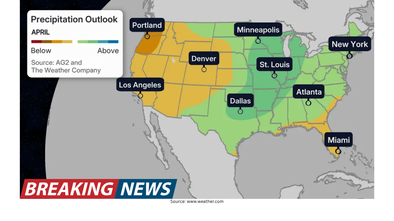
Precipitation outlook: wetter-than-average for much of the Central U.S.
Alongside the temperature map, the April precipitation outlook points to wetter-than-average conditions for much of the Central U.S. The update specifically notes that the wetter-than-average forecast for the Central Plains has been slightly expanded.
This expansion indicates a broader area where precipitation totals for April are expected to exceed typical amounts. As with temperatures, precipitation outlooks describe the overall monthly tendency rather than guaranteeing frequent rain every week. Still, a wetter signal across the Central U.S. can be a defining feature of the month—particularly when it overlaps with temperature anomalies.
The outlook also explains an important interaction between precipitation and temperatures. A small region of above-average temperatures in the Central U.S. is associated with increased precipitation that can keep average temperatures “down a bit.” This highlights a common springtime dynamic: more clouds and rainfall can limit daytime heating, affecting how warm the month feels overall.
Why the pattern looks this way: jet stream and storms in the Northeast
The outlook describes two main factors shaping the map, beginning with the Northeast. The region’s cooler-than-average expectation is linked to the jet stream’s seasonal behavior. Specifically, a slow track to the north of the jet stream—typical of this time of year—can steer more storms into the Northeast.
More storms can suppress temperatures in several ways. Storms often bring cloud cover, precipitation, and cooler air masses. Even when temperatures briefly rise between systems, repeated storm passages can keep the monthly average below normal.
This is why a stormier pattern can matter as much as the temperature of any single air mass. Over the course of a month, frequent disturbances can shape the overall average and reinforce a cooler signal.
The polar vortex: how changes can push cool air south and warm the West
The second major factor discussed is the polar vortex, described as a low-pressure system spinning at the North Pole. The outlook explains that when this low is strong, cool air tends to remain “stuck at the poles.” When it weakens, cooler temperatures can plunge south along the Northeast.
This kind of pattern can help explain the contrast between regions. The same configuration that allows cooler air to dip into the Northeast can also support warmer conditions in the West. In the updated April outlook, that west-to-east contrast is a key theme: widespread warmth across the West and much of the country, with the Northeast remaining cooler.
It’s important to interpret this as a broad atmospheric influence rather than a precise schedule of cold outbreaks. The outlook’s point is that the polar vortex pattern can tilt the odds toward certain regional outcomes over the course of the month.
ENSO transition: La Niña fading and El Niño developing
The outlook also notes a major shift in the broader climate background state. The La Niña that was ongoing during the winter has largely subsided, and an El Niño is on the way. The update states that this El Niño is expected to be strong and that it can contribute to temperature patterns over the coming months.
While the April outlook is the focus here, the mention of El Niño is included as an additional factor that may influence conditions beyond April as well. These large-scale ocean-atmosphere patterns can affect storm tracks and temperature distributions, which is why they are often referenced in seasonal outlook discussions.
The outlook includes a specific caution about summer heat risk in the eastern U.S. With the emergence of a strong El Niño over the next few months, the update warns that this could limit the risks for “big heat” across the eastern U.S. this summer, with the most anomalous heat extending from Texas northwestward to the Pacific Northwest.
This statement is framed as a risk assessment rather than a guarantee. It suggests that, in the months ahead, the strongest departures from typical heat may be more likely to focus from Texas toward the Pacific Northwest rather than concentrating in the East.
How to read an outlook like this
Monthly outlooks are best understood as probability-based guidance. They do not promise that every location will be warm every day in a warmer-than-average region, or cool every day in a below-average region. Instead, they describe the most likely overall outcome for the month compared with long-term averages.
In this updated April outlook, the dominant signal is warmth across a large portion of the country, with the Northeast standing out as the primary cool region. The precipitation outlook adds another layer, emphasizing wetter-than-average conditions for much of the Central U.S. and a slightly expanded wet signal for the Central Plains.
The changes from the prior forecast—especially the Southeast upgrade and the removal of a below-average zone in the Pacific Northwest and Northern Plains—underscore that outlooks can evolve as the atmosphere does. For anyone making plans that depend on typical April weather, the updated map provides a clearer sense of where the month may deviate most from normal and why those deviations are expected.
Key takeaways from the updated April outlook
- Above-average temperatures are expected from the Pacific Northwest to the Southwest, through the Central U.S., and into the Southeast.
- The Northeast is the main region forecast to be below average again.
- The Southeast has been upgraded to well above average temperatures compared with the previous forecast.
- The Pacific Northwest and Northern Plains shifted warmer, removing a previously forecast below-average area.
- Wetter-than-average conditions are expected for much of the Central U.S., with the wet signal slightly expanded in the Central Plains.
- The pattern is linked to the jet stream’s storm track influence in the Northeast, polar vortex behavior, and a transition from La Niña toward a developing, strong El Niño.
As April unfolds, these signals provide a framework for understanding what “normal” may look like this year—and where the month is most likely to depart from it.