
Tornado Touchdowns Reported in Kankakee and Northwest Indiana as Severe Storms Sweep the Region
Storm outbreak brings reported tornado touchdowns to Kankakee County
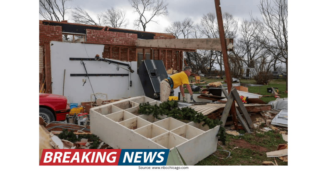
Emergency crews in Kankakee, Illinois, were assessing damage Tuesday afternoon after a tornado touched down amid a broader outbreak of severe weather across the region. The National Weather Service described a stovepipe tornado that was spotted near the Kankakee Airport and tracked toward Aroma Park, Illinois, before continuing on toward Momence.
Another tornado touchdown was also reported at the Kankakee County Fairgrounds. In the immediate aftermath, responders focused on evaluating impacts and addressing hazards created by the storm.
Visible damage reported, including downed power lines
A meteorologist on scene in Kankakee County reported significant damage in the area where the touchdown occurred, including damage to homes and downed power lines. Downed lines can create dangerous conditions even after storms move out, and officials urged residents not to attempt to assess damage on their own.
That message was echoed across the state line as well, where confirmed tornadoes were reported over parts of northwest Indiana. Emergency crews there advised residents to stay put and avoid going outside to inspect damage themselves.
Watches and warnings: what was in effect overnight
As the situation evolved late Tuesday, there were no active tornadoes and no severe thunderstorm or flash flood warnings in effect within the viewing area at the time of the update. No severe thunderstorm watches were in effect either. However, a Tornado Watch remained in place for La Porte County until 1 a.m.
Flooding concerns persisted. A Flood Watch was in effect for multiple counties in Illinois—Cook, DuPage, Will, Grundy, Kane, Kankakee, Kendall, and La Salle—as well as Lake and Porter counties in Indiana, through 3 a.m. Wednesday.
Chicago hit by fast-changing conditions: downpour followed by hail
The severe weather reached downtown Chicago shortly before 6:30 p.m. What began as a typical thunderstorm quickly intensified, shifting into a heavy downpour and then an onslaught of hail. The rapid progression underscored how quickly conditions can deteriorate during high-end severe weather setups.
Forecasters noted that storm chances were expected to gradually decrease after midnight, with the most concerning window for severe storms and tornadoes focused on Tuesday evening.
Large hail reported across the area, including very large stones in Kankakee
Hail reports came in from several locations, with especially large hail noted in and around Kankakee. One report cited hail as large as 5.2 inches in Kankakee—an amount that was described as potentially a record for Illinois. Other hail sizes reported included ping pong ball-sized hail in Romeoville and tennis ball-sized hail near Pontiac, Illinois. Golf ball-sized hail was also reported in Bolingbrook.
In addition to hail, storms were expected to be capable of damaging wind gusts up to 70 miles per hour. Forecasters also warned that hail could potentially reach tennis-ball size in some locations.
Risk outlook: tornadoes, hail, wind damage, and flooding
Meteorologists described the overall severe weather risk as among the highest seen in several years. With that level of threat, they stressed the importance of having multiple ways to receive warnings and being ready to act quickly if a warning is issued.
Heavy rain was also a major concern, particularly Tuesday night. Slow-moving storms could repeatedly pass over the same areas, increasing the risk of localized flooding and flash flooding. The broader Chicago area was described as facing a high risk for flooding, a medium to high risk for wind damage, and a high risk for tornadoes and hail through 1 a.m. Wednesday.
Areas along and south of I-80 and in northwest Indiana were identified as having the greatest risk for tornadoes, with a level four (moderate) threat of severe storms Tuesday. While the risk was greatest in those areas, forecasters also said the entire area—including the city—had an enhanced chance of severe weather. There was also a risk of long-tracked tornadoes.
How the threat differed north and south of I-80
Forecast guidance highlighted a geographic split in storm hazards. In areas along and south of I-80, storms could produce damaging winds, large hail, and tornadoes. Farther north, storms could still develop, but were more likely to produce hail and gusty winds rather than tornadoes, due to cooler and more stable air near the lake.
Even where tornado potential was lower, the combination of hail, strong winds, and heavy rain still posed significant risks to people, property, and travel.
Community response: storm shelters opened in Manteno
With severe weather anticipated, local officials took steps to provide shelter options for residents without basements. The Manteno Police Department announced that two storm shelters would be open for those needing a safer place to ride out the storms.
- St. Joseph Catholic Church, 207 S. Main St. (enter through the south lower doors leading directly to the basement)
- Manteno Church of the Nazarene, 698 N. Locust St. (enter through the main doors and turn right to reach the basement)
Officials noted that no animals were allowed at either shelter.
Safety guidance during tornado warnings
For residents in the path of tornado-producing storms, officials emphasized taking immediate protective action when warnings are issued. If a tornado warning is issued for your area, guidance included taking shelter in the lowest level of a home or in a basement when possible. If a basement is not available, people were advised to move to an interior room away from windows—such as a bathroom, closet, or hallway.
If time allows, residents were advised to bring pets into the shelter area with them.
What to do if you are outside or in a vehicle
For those caught outdoors, guidance was to seek shelter inside a sturdy building immediately. Sheds, storage facilities, and mobile homes were not considered safe shelter locations by the National Weather Service.
If you are in a car, the advice was to drive to the closest shelter and take cover. If you cannot reach a safe shelter, the National Weather Service advised either getting down in the car and covering your head, or abandoning the vehicle and seeking shelter in a low-lying area such as a ditch or ravine.
Preparing a safe room: practical items to bring
In addition to choosing a safe location, residents were encouraged to bring key items into a safe room if possible. Suggested items included a flashlight, water, and a phone with a charger. If available, a radio was also recommended so people could stay informed about weather alerts, changing conditions, and when warnings have been cleared.
Understanding tornado watches versus tornado warnings
Officials also reiterated the difference between a tornado watch and a tornado warning—an important distinction when severe weather is unfolding quickly.
- Tornado watch: Conditions are favorable for severe storms and tornadoes to form. When a watch is issued, residents are advised to prepare in case a warning is later issued, including gathering supplies and identifying the safest place to shelter.
- Tornado warning: A tornado has been sighted or indicated by weather radar, signaling imminent danger to life and property. When a warning is issued, residents should take shelter immediately and follow safety precautions.
Watches typically cover large areas that could be at risk, while warnings are issued for smaller areas—often around the size of a city or a small county—where a tornado has been identified by radar or confirmed by a trained spotter.
Power outage preparedness and downed line hazards
With storms bringing the potential for damaging winds and falling debris, the risk of power outages was a key concern. The region’s electric utility said it was preparing ahead of time for possible outages as severe thunderstorms moved through its service territory Tuesday afternoon and night. The utility said all available crews were committed to working around the clock to restore outages and keep customers safe.
In storm-related outages, the utility said its first priority is restoring power to critical facilities such as police and fire stations, nursing homes, and hospitals. After that, repairs are made to restore power to the greatest number of customers.
Residents were also warned about the dangers of downed power lines. Approaching downed lines was described as unsafe, and an immediate report to the utility was urged if a power line comes down. The utility also advised that people should not approach workers in the field to ask about restoration times, noting they may be working on live electrical equipment and that entering work zones can be dangerous.
Conditions easing after midnight, but flood concerns linger
While forecasters expected storm chances to gradually decrease after midnight, the impacts of the evening’s severe weather could last longer—particularly where heavy rain fell repeatedly. With Flood Watches in effect into early Wednesday, residents in affected counties were urged to remain alert to changing conditions overnight.
As crews continued damage assessments in Kankakee County and residents in northwest Indiana were urged to stay put, the broader message from officials remained consistent: monitor alerts closely, take warnings seriously, and prioritize safety until the threat fully passes.